We deploy a multi-electrode array connected to a resistivity meter right on the Moncton jobsite, injecting a controlled DC current into the ground through stainless steel stakes. The measured potential drop reveals how easily the subsurface materials conduct electricity—a property that shifts dramatically between the dense glacial till, saturated silts, and sandstone bedrock typical of Greater Moncton. In a city where the Petitcodiac River has deposited meters of compressible alluvium over fractured Carboniferous bedrock, knowing what lies beneath a proposed foundation before breaking ground avoids expensive surprises. This is where a test pit can physically verify a resistivity anomaly, or where CPT soundings provide a continuous mechanical profile to cross-check the electrical sections, giving contractors a complete picture of the ground they are building on.
A resistivity contrast of 10 ohm-m versus 200 ohm-m often marks the boundary between saltwater-influenced silts and competent bedrock in the Moncton area.
Technical details of the service in Moncton
Critical ground factors in Moncton
Under the National Building Code of Canada (NBCC), Moncton falls within a seismic hazard zone that requires accounting for site class effects. The Moncton Sub-basin’s thick sequences of Albert Formation silts and shales amplify ground motion differently than the harder Petitcodiac sandstone ridges, making a uniform site classification a gamble. Ignoring a high-conductivity clay layer at depth, for instance, leads to underpredicting settlement under a footing load—or worse, misidentifying a liquefiable sand lens during a seismic assessment. A resistivity survey performed before the geotechnical drilling phase directs the borehole locations to the critical spots, so the investigation budget targets the highest-risk materials rather than spreading evenly over a site that looked homogeneous from the surface.
Our services
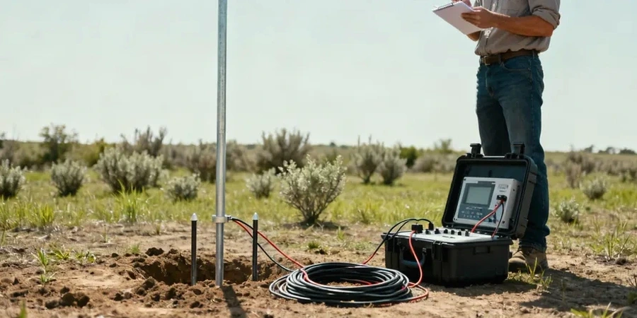
Our electrical resistivity service in Moncton covers everything from pre-construction site screening to forensic investigations of failing infrastructure. Each survey is designed around the specific geologic questions of the project, not a one-size-fits-all template.
VES Depth Soundings for Foundation Design
We run one-dimensional vertical electrical soundings at proposed footing or pile locations to map geo-electric layers and estimate bedrock depth, feeding directly into the geotechnical model for the structural engineer.
2D Resistivity Imaging for Linear Infrastructure
For pipeline routes, road expansions, and trenchless installations across Moncton’s river crossings, we deploy multi-electrode cable spreads to produce continuous cross-sections that highlight buried channels and weak zones.
Groundwater and Saltwater Intrusion Mapping
Near the Petitcodiac causeway and tidal flats, resistivity distinguishes fresh groundwater from brackish intrusion, helping contractors plan dewatering and evaluate concrete durability risks per CSA exposure classes.
Common questions
How deep can a resistivity survey see in Moncton’s geology?
With a Schlumberger array and a maximum current-electrode spread of 200 meters, we routinely reach investigation depths of 45–60 meters. The actual penetration depends on the near-surface resistivity; the conductive clays of the Moncton Sub-basin limit depth somewhat compared to the resistive sandstone ridges, so we model the expected current penetration during survey design and adjust the geometry if the target requires deeper coverage.
What does a resistivity survey cost for a typical commercial lot in Moncton?
For a standard commercial lot—say 2,000 to 4,000 square meters with two to three VES soundings or a short 2D line—the fee runs between CA$920 and CA$1,520. The range depends on the number of electrode spreads, the required depth of investigation, and whether we need to clear brush or cross asphalt to place electrodes.
Can resistivity tell the difference between wet clay and clean sand?
Yes, reliably. Saturated clay in the Moncton area typically reads below 30 ohm-m, while clean, water-bearing sand falls between 50 and 200 ohm-m depending on grain size and groundwater salinity. The transition is sharp enough that we can map clay lenses within a sandy matrix, which is exactly the kind of detail a structural engineer needs to predict differential settlement under a mat foundation.
How long does a field survey take?
A set of four vertical electrical soundings on a half-acre lot is generally completed in one field day. 2D imaging along a 200-meter line with a multi-electrode system takes four to six hours including setup and breakdown. We provide preliminary cross-sections within 48 hours and the full interpretation report within five business days, faster if the project schedule requires it.